Volusia Forever

Banner Image with VF for Volusia Forever. Background is an oak forested area.

Explore Volusia County's breathtaking preserved lands, where crystal-clear springs, lush forests, and diverse wildlife await your discovery. Our conservation program protects thousands of acres of natural habitat, offering visitors endless opportunities for hiking, birdwatching, paddling, and connecting with Florida's unique ecosystems. Through collaborative partnerships, Volusia County has successfully conserved 37% of its total acreage—a total of 59,800 acres—with an ambitious goal to reach 50% conservation in the future.

These carefully maintained sanctuaries not only safeguard our precious water resources and biodiversity but also provide perfect settings for outdoor adventures and educational experiences. Come witness the natural beauty that Volusia Forever has protected for generations to come, and create unforgettable memories in our pristine landscapes.

FEATURED SPOTLIGHT

Deep Creek Preserve
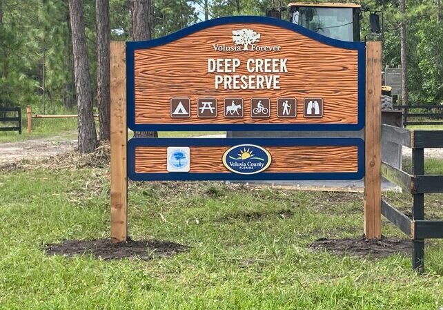
Sign for Deep Creek
Tortoise at Deep Creek Preserve
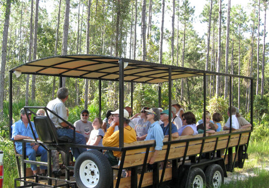
Tour Buggie at Deep Creek Preserve

With miles of trails and diverse wildlife, Deep Creek Preserve invites visitors to experience the best of Florida’s great outdoors. Covering 8,040 acres, this extensive landscape features a blend of pristine wilderness and historic agricultural land, providing a glimpse into Florida’s natural beauty and conservation efforts.

Originally a cattle ranch and timber operation, the preserve was acquired in 2010 through Volusia Forever and Volusia County Water and Utilities. In 2011, the St. Johns River Water Management District added an additional parcel. Together, these lands play a crucial role in creating a connected wildlife corridor, ensuring safe passage for native species, and preserving critical habitats.

As you embark on the 4.4-mile yellow trail, keep an eye out for southern fox squirrels, gopher tortoises, otters, deer, and even black bears that call this area home. The  landscape shifts from pine flatwoods and hydric hammocks to cypress domes and  trands, offering every turn as a new opportunity to experience Florida’s diverse  ecosystems. Ongoing conservation efforts, including timber management, prescribed  burns, and habitat restoration, continue to enhance the preserve’s natural beauty and  upport local wildlife.

Whether you’re hiking, observing wildlife, or simply enjoying the serene surroundings, Deep Creek Preserve provides an escape into Florida’s wild side. Just remember to pack plenty of water, respect the land, and carry out your trash—let’s keep this slice of paradise as wild as it was meant to be.

Graphic Element - Blue Wavy Line

Learn More About Other Projects Below:

The 8,040-acre Deep Creek Preserve includes both natural and agricultural features. The site consists of two acquisitions: the first, a cattle ranch and timber operation was purchased in 2010 with funds form Volusia Forever and Volusia County Water and Utilities. The second parcel, located to the north was acquired by the St. Johns River Water Management District in 2011. Both acquisitions contribute to the goal of creating a connected wildlife greenway in the Volusia Conservation Corridor. Resource management for the entire Preserve is handled by Volusia County Resource Stewardship Division.
The Preserve includes 3,400 acres for planted pine along the pine flatwoods, hydric hammocks, cypress strands, and cypress domes. Long term forest management will be utilized on this site to improve forest habitat for wildlife. This will include timbering, planting, mowing, chopping and extensive preserved burning.
Along the 4.4 mile yellow trail, visitors can experience and explore the plant and animal life of the Florida habitats. Southern fox squirrels, gopher tortoise, otter, deer and black bear may be observed on the trail. Visitors should bring adequate drinking water and carry out their trash.
We hope that you enjoy your visit.

The Preserve is 1,385 acres of conservation land featuring Deep Creek, a five mile body of water that crosses the property as it flows to the St. Johns River. The natural community types here include pine flatwoods, cypress domes, and floodplain swamps. Great blue heron, osprey, bald eagle, alligator, river otter, bobcat, deer and turkey make their homes here. This scenic preserve is on 2,513 acres in Port Orange. Its 536-foot boardwalk begins more than three miles of nature trails leading to the 15-foot observation tower and continues to Rose Bay. The tower overlooks the marsh area near Spruce Creek.The extension began on the north side of the park as part of the Rose Bay Legacy Project Program under the direction of a teacher at Mainland High School. The students notched out minimum-impact nature trails and planted native vegetation throughout the area while studying the environment. Students from Mainland High School, Campbell Middle School, South Daytona Elementary, Holly Hill Elementary, and many other students and teachers have worked with community members and state and county agency mentors to help construct trails, monitor the environment, remove exotic species, and renourish the wetlands.Volusia County conservation lands are managed using a program of professionally accepted principles of resource and ecosystem management for the benefit of and enjoyment by, present and future generations. Gemini Spring Conservation Area was acquired from the St. Johns River Management District in March of 2017. The property consists of 48% upland and 52% wetland and open water. The water bodies that are located within or touching the property are Mullet Lake, DeBary Creek, Borrow Pond, Lake Monroe and the St. Johns River. Numerous wildlife species can be observed on site.Volusia County Land Management Division is responsible for the resource management of this conservation area. The 150-acre Hickory Bluff Preserve overlooks the St. Johns River and contains many natural communities including mesic and scrubby flatwoods, oak hammock, cypress domes, floodplain swamp, and wet prairie.While hiking the trails, you may identify distinct natural communities by the presence of certain plants:• Scrubby flatwoods are characterized by an overstory of pines, a midstory of rusty lyonia and sand live oak, and an understory of palmetto that is common along the blue and red trails. • Oak hammocks, which occur in the presence of longterm fire suppression, are characterized by an overstory of tall oaks and an understory lacking diversity and are common along the blue trail near the river bluff and around the pavilion.• Cypress domes, along both trails, are characterized by a dome-like appearance of a cypress stand tree-line.• The floodplain swamp along the blue trail by the river is characterized by bald cypress, hickory, ash and slow moving black water. • Wet prairie are characterized by open areas of herbaceous vegetation such as grasses, sedges and wildflowers.The preserve was acquired by Volusia County Government using Volusia Forever funds with the assistance of a grant from the Florida Communities Trust. Wildlife along the trail many include osprey, eagle, great blue heron, barred owl, gopher tortoise, alligator, river otter, bobcat, deer and turkey.Volusia County conservation lands are managed using a program of professionally accepted principles of resource and ecosystem management for the benefit of, and enjoyment by, present and future generations.


The 8,062-acre Lake George Forest and Wildlife Management Area is part of a 35,380-acre wildlife management area that provides more than 20 miles of contiguous habitat for many species of Florida’s wildlife along Lake George and the St. Johns River.
Two marked trails lead to several of Florida’s natural communities including pine flatwoods, cypress swamps, and marsh. The blue trail passes Lake George, the second largest lake in Florida and the largest lake along the St. Johns River.
The Lake George area has the second largest population of bald eagles in the lower 48 states.
The 4.2-mile horse trail, which begins at the horse trail parking lot off Ninemile Point Road, passes several plant communities, both natural and planted.
Pine flatwoods, which dominate the site, are characterized by an overstory of slash and longleaf pine, a midstory of bays, wax myrtle, and water oaks and an understory of gallberry and palmettos.
The conservation area was acquired in 1990 by Volusia County and the St. Johns Water Management District. Volusia County used funds from the Environmentally Endangered Lands program that was approved by the county's voters in 1986. Previously, the land was owned by the Union Camp Paper Co., which used it for timber production.
The trail along Lake George winds through hardwood hammock dominated by live oak, sweet bay, magnolia, and sabal palm with an understory of palmetto. Wildlife along the trails may include osprey, bald eagle, barred owl, pigmy rattlesnake, black bear, bobcat, river otter, fox, deer and turkey.
Volusia County conservation lands are managed using a program of professionally accepted principles of resource and ecosystem management for the benefit of, and enjoyment by, present and future generations.

Longleaf Pine Preserve includes several natural communities, including mesic and wet flatwoods, cypress strands, cypress domes and scrub.The preserve, which covers 12,005 acres, has two long marked trails:• The red trail is a 7 mile loop that begins and ends at the west entrance of the preserve. Along this trail, visitors may see mesic flatwoods, which are characterized by longleaf pine and slash pine and an understory dominated by saw palmetto and wiregrass. Cypress domes may be recognized along the red trail and throughout the site by the dome-like appearance of their pond cypress tree line. Cypress strands - elongated areas of cypress tree communities - also can be seen in the distance.• The blue trail begins at the east entrance and crosses 6 miles of the preserve. It no longer connects to the red trail, so hikers and equestrians must turn around at the terminus. Signs are posted. The east end of the blue trail traverses through wet flatwoods with an overstory of slash pine and an understory of saw palmetto, gallberry and seasonal wildflowers. The central portion of the blue trail winds through cypress strand swamp. The absence of tall cypress in the central portion is due to heavy logging.The blue and red marked trails are open to hiking, biking and horseback riding. Portions of the trail are subject to flooding - some areas possibly more than two feet. Although use of the trail when flooded may not be for everyone, traversing this natural site under wet conditions provides an opportunity to observe and experience the character of Florida's vital wet habitats. Lyonia Preserve is a joint project of Volusia County, the Volusia County School Board and the State of Florida to provide environmental education to the public and restore and maintain habitat for scrub-dependent species, including the threatened scrub jay and gopher tortoise. The preserve, named after the scrub plant rusty lyonia, consists of 360 acres of restored Florida scrub habitat.This preserve and other Volusia County conservation lands are managed using a program of professionally accepted principles of resource and ecosystem management for the benefit of, and enjoyment by, present and future generations.Scrub habitat - The scrub on Lyonia Preserve is an imperiled Florida ecosystem that is found on high sandy ridges and is dominated by short oaks and other low vegetation, numerous open areas of white sand, and very few tall trees. Many of the plants and animals living in the scrub habitat are fully dependent upon these characteristics for their survival and success. This is especially true of the most fascinating resident, the Florida scrub jay (volusia.org).Florida scrub, where plants and animals have adapted industrious and clever means to survive and succeed in harsh conditions, is designated as an imperiled habitat. Scrub is the only place where the Florida scrub jay can be found. Scrub jays are Florida’s only endemic bird and are listed as a threatened species. Mechanical treatments such as roller chopping and mowing are used to keep the vegetation low and suitable for the scrub jay. Scrub jays need expanses of low shrubs and sandy areas with little to no tree coverage. Generally, suitable scrub is low enough to allow a 6-foot tall person to see over most of the landscape plants.Trails - Three hiking trails (0.4 miles, 1.2 miles, and 2.4 miles) wind through the conservation land, starting behind the Deltona Regional Library and Lyonia Environmental Center. Along these trails, visitors may observe more than 164 species of plants and more than 124 species of animals. Experiencing Florida scrub is a lesson in the intricate web of an ecosystem. There is no shade in Lyonia Preserve. Trail conditions are soft, deep sand. Wear closed-toe shoes and bring a bottle of water. Scrub Oak Preserve encompasses 134 acres purchased through the Volusia Forever Program in 2008. The preserve is an important bear corridor to Blue Spring State Park and the Lake Beresford area. Porous scrub soils also make it an important recharge area for Blue Spring. The Preserve includes 70 acres of scrub habitat that was dominated by mature oaks and sand pines at the time of purchase. This scrub area has undergone extensive habitat restoration including timbering, mechanical treatment and prescribed fire. The goal of these ongoing land management activities is to remove the tree canopy, reduce vegetation height and create open sandy areas for Florida scrub jay (volusia.org) and other scrub flora and fauna that depend on these desert-like conditions. Scrub jays from adjacent sites have already moved into the restoration area.The Preserve has a one mile loop trail which allows visitors to experience scrub and all its unique adaptations to survive in this hot, dry habitat. Some of the plants hikers will observe are rusty lyonia, tarflower, shiny blueberry and scrub olive. Wildlife that has been observed on site includes Florida scrub jays, Florida black bear, gopher tortoise and osprey.Volusia County conservation lands are managed using a program of professionally accepted principles of resource and ecosystem management for the benefit of, and enjoyment by, present and future generations. Wiregrass Prairie Preserve consists of 1,423 acres situated almost entirely in the St. Johns River valley.The preserve is a mosaic of upland and wetland natural communities including mesic and wet flatwoods, cypress domes, strand swamp and wet prairie.While hiking the preserve's five trails, you may identify distinct natural communities by the presence of certain plants:• Mesic and wet flatwoods are characterized by an overstory of slash and longleaf pine scattered across the landscape with an understory dominated by saw palmetto and wiregrass (seen on the blue trail).• Cypress domes may be recognized from a distance by the dome-like appearance of their tree line, and can be observed on all three trails.The land was acquired in 2002 by the St. Johns River Water Management District and Volusia County Government using Volusia Forever funds. The strand swamp east of the blue and orange trails can be identified by the presence of pond cypress, pond pine and loblolly bay.Wet prairies on the orange trail are open areas dominated by St. Johns wort species and other wildflowers such as pipewort, batchelor’s button, and meadow beauty.Volusia County conservation lands are managed using a program of professionally accepted principles of resource and ecosystem management for the benefit of, and enjoyment by, present and future generations. This scenic preserve is on 2,513 acres in Port Orange. Its 536-foot boardwalk begins more than three miles of nature trails leading to the 15-foot observation tower and continues to Rose Bay. The tower overlooks the marsh area near Spruce Creek.The extension began on the north side of the park as part of the Rose Bay Legacy Project Program under the direction of a teacher at Mainland High School. The students notched out minimum-impact nature trails and planted native vegetation throughout the area while studying the environment. Students from Mainland High School, Campbell Middle School, South Daytona Elementary, Holly Hill Elementary, and many other students and teachers have worked with community members and state and county agency mentors to help construct trails, monitor the environment, remove exotic species, and renourish the wetlands.Volusia County conservation lands are managed using a program of professionally accepted principles of resource and ecosystem management for the benefit of and enjoyment by, present and future generations. This scenic preserve is on 2,513 acres in Port Orange. Its 536-foot boardwalk begins more than three miles of nature trails leading to the 15-foot observation tower and continues to Rose Bay. The tower overlooks the marsh area near Spruce Creek.The extension began on the north side of the park as part of the Rose Bay Legacy Project Program under the direction of a teacher at Mainland High School. The students notched out minimum-impact nature trails and planted native vegetation throughout the area while studying the environment. Students from Mainland High School, Campbell Middle School, South Daytona Elementary, Holly Hill Elementary, and many other students and teachers have worked with community members and state and county agency mentors to help construct trails, monitor the environment, remove exotic species, and renourish the wetlands.Volusia County conservation lands are managed using a program of professionally accepted principles of resource and ecosystem management for the benefit of and enjoyment by, present and future generations. This scenic preserve is on 2,513 acres in Port Orange. Its 536-foot boardwalk begins more than three miles of nature trails leading to the 15-foot observation tower and continues to Rose Bay. The tower overlooks the marsh area near Spruce Creek.The extension began on the north side of the park as part of the Rose Bay Legacy Project Program under the direction of a teacher at Mainland High School. The students notched out minimum-impact nature trails and planted native vegetation throughout the area while studying the environment. Students from Mainland High School, Campbell Middle School, South Daytona Elementary, Holly Hill Elementary, and many other students and teachers have worked with community members and state and county agency mentors to help construct trails, monitor the environment, remove exotic species, and renourish the wetlands.Volusia County conservation lands are managed using a program of professionally accepted principles of resource and ecosystem management for the benefit of and enjoyment by, present and future generations. This scenic preserve is on 2,513 acres in Port Orange. Its 536-foot boardwalk begins more than three miles of nature trails leading to the 15-foot observation tower and continues to Rose Bay. The tower overlooks the marsh area near Spruce Creek.The extension began on the north side of the park as part of the Rose Bay Legacy Project Program under the direction of a teacher at Mainland High School. The students notched out minimum-impact nature trails and planted native vegetation throughout the area while studying the environment. Students from Mainland High School, Campbell Middle School, South Daytona Elementary, Holly Hill Elementary, and many other students and teachers have worked with community members and state and county agency mentors to help construct trails, monitor the environment, remove exotic species, and renourish the wetlands.Volusia County conservation lands are managed using a program of professionally accepted principles of resource and ecosystem management for the benefit of and enjoyment by, present and future generations. Longleaf Pine Preserve includes several natural communities, including mesic and wet flatwoods, cypress strands, cypress domes and scrub.The preserve, which covers 12,005 acres, has two long marked trails:• The red trail is a 7 mile loop that begins and ends at the west entrance of the preserve. Along this trail, visitors may see mesic flatwoods, which are characterized by longleaf pine and slash pine and an understory dominated by saw palmetto and wiregrass. Cypress domes may be recognized along the red trail and throughout the site by the dome-like appearance of their pond cypress tree line. Cypress strands - elongated areas of cypress tree communities - also can be seen in the distance.• The blue trail begins at the east entrance and crosses 6 miles of the preserve. It no longer connects to the red trail, so hikers and equestrians must turn around at the terminus. Signs are posted. The east end of the blue trail traverses through wet flatwoods with an overstory of slash pine and an understory of saw palmetto, gallberry and seasonal wildflowers. The central portion of the blue trail winds through cypress strand swamp. The absence of tall cypress in the central portion is due to heavy logging.The blue and red marked trails are open to hiking, biking and horseback riding. Portions of the trail are subject to flooding - some areas possibly more than two feet. Although use of the trail when flooded may not be for everyone, traversing this natural site under wet conditions provides an opportunity to observe and experience the character of Florida's vital wet habitats.